Build a Conceptual Model of Your
Problem Domain
The Argus Open Numerical Environments (Argus ONE) enable you to begin your work by creating a conceptual model of your problem domain. For each of the domain characteristics, you define Information, Data or Maps Layers, which are data bases containers and into which you then import your information. If your problem domain definition involves many parameters, or is made of many geological formations, each having many parameters defining it, you can create as many information layers as required to store all of the different information types.
By setting relations and links between information and data layers you create a data flow model which enables you to define new entities needed to describe your problem domain. Thus you can create relations such as the thickness of a geological formation by subtracting its top and bottom topography maps. Each object you create or import into information layers is a GIS object having a graphical representation and a data representation which you can edit on screen.
Dynamic Information Linking
Linking your data flow to numerical grids and meshes enables you to make your data available for your numerical model. By storing your conceptual model and your information in linked layers, and not directly on your grids and meshes, Argus ONE allow you to refine your meshes and grids while it automatically reassigns the data to them. Argus ONE is the only product in the market that supports dynamic information linking.
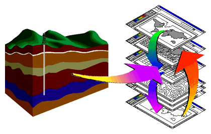
Creating a conceptual model is performed by just clicking buttons in the Layers Dialog to create layers and naming the layers to reflect their contents. Each layer can be assigned as many layer parameters as needed, which serve as the layer's data base fields. Thus, if for instance your information file holds the Kx, Ky, Kz components' of the distribution of a physical parameter, you can create three layer parameters to hold each of the components.

To transform the conceptual model to a model of your specific problem domain all you have to do is to import your information files into the layers you've defined. Argus ONE support many file formats for importing your information, such as DXF, Argus ONE contour format, and scattered data. The information you import is stored as dynamic objects having both data base and graphical representations, enabling you to view and edit their "shape/location" as well as their values.
The following picture demonstrates how a contour map representing the spatial distribution of a parameter such as topography, bathymetry, concentration, or initial head distributions can be imported into the Argus Open Numerical Environments Workplace.

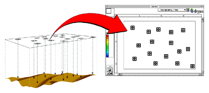
The following picture demonstrates how a scattered data file representing the surveyed distribution of a parameter can be imported into the Argus Open Numerical Environments Workplace.
To next page of introduction
To find out more about Argus and its products email marketing@argusone.com or call:
+972-9-957-5752
Tech. support: support@argusone.com
snail mail: Argus Holdings, POB 6254, Herzelia, 46160, Israel
Copyright © Argus Holdings, Ltd. 1992-2015
